Property Record
1910 Berryman St, Berkeley, CA 94709


Save to a Folder
{{folder.Name}}
{{folder.ListingIds.length}} Properties
{{folder.ListingIds.length}} Property
Create a New Folder
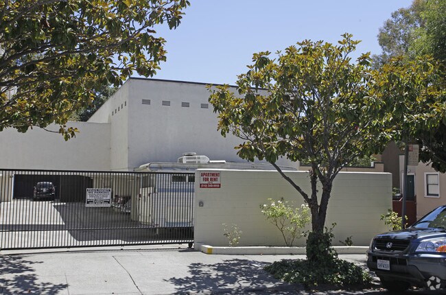
Property Detail
1910 Berryman St
Oakland-Fremont-Berkeley, CA
LOT: 00001 BLK: PM: 0216 PAGE: 0040 ;LOT: 00001 BLK: 0004 AR: 0060 PAGE: 2448 ;LOT: 00001 BLK: 0008 AR: 0055 PAGE: 1898
060-2448-004-01
Alameda
Multifamilydwelling
California
B and X Area of moderate flood hazard, usually the area between the limits of the 100-year and 500-year floods.
1,2
2025
0.45 AC
2025
North Berkeley
421700
East Bay/Oakland
22,237 SF
NEARBY LISTINGS FOR SALE OR LEASE
-
-
-
-
-
-
-
-
-
-
-
-
-
-
-
-
-
No Photo
-
-
-
-
-
-
-
-
-
-
-
-
-
-
View all Berkeley listings for sale on LoopNet.com
DEMOGRAPHICS near 1910 Berryman St
1 mile
3 mile
5 mile
2025 Total Population
37,253
190,530
349,389
2030 Population
37,365
190,802
350,964
Pop Growth 2025-2030
+ 0.30%
+ 0.14%
+ 0.45%
Average Age
42
40
41
2025 Total Households
15,839
74,899
142,407
HH Growth 2025-2030
+ 0.35%
+ 0.21%
+ 0.53%
Median Household Inc
$119,063
$114,659
$117,445
Avg Household Size
2.20
2.30
2.20
2025 Avg HH Vehicles
1.00
1.00
1.00
Median Home Value
$1,113,965
$1,094,783
$1,065,895
Median Year Built
1947
1949
1955
Nearby Places
Map Layers
Map Styles
 Street
 Aerial
Layers
 Traffic
 Biking
Places
Listings with unknown addresses are not visible on the map
- Restaurants
- Banks
- Shops
- Fitness
- Groceries
PUBLIC TRANSPORTATION
COMMUTER RAIL
Drive
Walk
Distance
9 min
2.9 mi
Drive
Walk
Distance
12 min
4.3 mi
AIRPORT
Metro Oakland International
Drive
Walk
Distance
Metro Oakland International
29 min
15.2 mi
San Francisco International
Drive
Walk
Distance
San Francisco International
42 min
25.6 mi
Freight Ports
Port of Oakland
Drive
Walk
Distance
Port of Oakland
17 min
6.9 mi
Nearby Properties
Address
Land Use
TOTAL SIZE
Lot Size
Zoning
Address
Land Use
TOTAL SIZE
Lot Size
Zoning
358,014 SF
5.03 AC
Address
Land Use
TOTAL SIZE
Lot Size
Zoning
167,071 SF
0.70 AC
Address
Land Use
TOTAL SIZE
Lot Size
Zoning
540,434 SF
14.37 AC
Address
Land Use
TOTAL SIZE
Lot Size
Zoning
395,549 SF
17.05 AC
Address
Land Use
TOTAL SIZE
Lot Size
Zoning
250,642 SF
17.05 AC
Address
Land Use
TOTAL SIZE
Lot Size
Zoning
261,134 SF
2.23 AC
Address
Land Use
TOTAL SIZE
Lot Size
Zoning
169,157 SF
10.20 AC
Address
Land Use
TOTAL SIZE
Lot Size
Zoning
224,160 SF
5.03 AC
Address
Land Use
TOTAL SIZE
Lot Size
Zoning
4.77 AC
Address
Land Use
TOTAL SIZE
Lot Size
Zoning
309,451 SF
0.87 AC
Address
Land Use
TOTAL SIZE
Lot Size
Zoning
60,670 SF
1.57 AC
Address
Land Use
TOTAL SIZE
Lot Size
Zoning
123,750 SF
0.81 AC
Address
Land Use
TOTAL SIZE
Lot Size
Zoning
254,000 SF
1.71 AC
Address
Land Use
TOTAL SIZE
Lot Size
Zoning
127,260 SF
5 AC
I
Address
Land Use
TOTAL SIZE
Lot Size
Zoning
166,731 SF
0.54 AC
Address
Land Use
TOTAL SIZE
Lot Size
Zoning
86,144 SF
0.52 AC
Address
Land Use
TOTAL SIZE
Lot Size
Zoning
126,087 SF
2.29 AC
Address
Land Use
TOTAL SIZE
Lot Size
Zoning
137,102 SF
3.63 AC
Address
Land Use
TOTAL SIZE
Lot Size
Zoning
159,705 SF
1.64 AC
COMM
Address
Land Use
TOTAL SIZE
Lot Size
Zoning
65,839 SF
0.62 AC
C2
Address
Land Use
TOTAL SIZE
Lot Size
Zoning
12.31 AC
Address
Land Use
TOTAL SIZE
Lot Size
Zoning
330,000 SF
117.76 AC
Address
Land Use
TOTAL SIZE
Lot Size
Zoning
0.61 AC
Address
Land Use
TOTAL SIZE
Lot Size
Zoning
3.61 AC
Address
Land Use
TOTAL SIZE
Lot Size
Zoning
90,594 SF
2.06 AC
Address
Land Use
TOTAL SIZE
Lot Size
Zoning
30,500 SF
0.24 AC
R4
Address
Land Use
TOTAL SIZE
Lot Size
Zoning
0.60 AC
Address
Land Use
TOTAL SIZE
Lot Size
Zoning
67,558 SF
0.32 AC
Address
Land Use
TOTAL SIZE
Lot Size
Zoning
136,811 SF
1.01 AC
Address
Land Use
TOTAL SIZE
Lot Size
Zoning
45,500 SF
1.79 AC
The World's #1 Commercial Real Estate Marketplace
Connect with us
© 2026 CoStar Group
The information above has been obtained from sources believed reliable. While we do not doubt its accuracy we have not verified it and make no guarantee, warranty or representation about it. It is your responsibility to independently confirm its accuracy and completeness. Any projections, opinions, assumptions, or estimates used are for example only and do not represent the current or future performance of the property. The value of this transaction to you depends on tax and other factors which should be evaluated by your tax, financial, and legal advisors. You and your advisors should conduct a careful, independent investigation of the property to determine to your satisfaction the suitability of the property for your needs.